


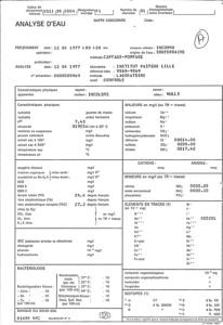
Identifiant national de l'ouvrage
BSS000AQWM
Ancien code - avant 2017
00115X0004
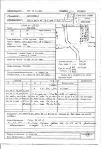
Localisation
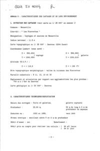
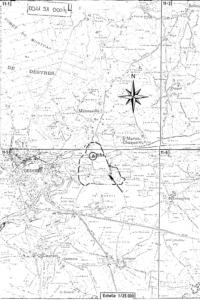
Département
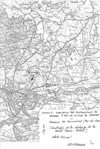
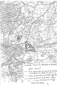
PAS DE CALAIS (62) - SGR/NPCCommune
MENNEVILLE (62566)Nom local
P1Numéro de carte
0011Huitičme
5XRégion naturelle
BOULONNAISBassin versant
LIANEAdresse ou Lieu-dit
LES PIERRETTESCoordonnées
| Systčme | X (m) | Y (m) |
|---|---|---|
| Lambert 2 étendu | 566369 | 2630574 |
| Lambert 1 - Nord | 566440 | 330070 |
| Lambert-93 | 619399 | 7064085 |
| Systčme | Latitude | Longitude |
|---|---|---|
| WGS84 | 50.66839987 | 50° 40' 6'' N | 1.86181628 | 1° 51' 42'' E |
Altitude
118.9 m - Précision EPDDescription technique
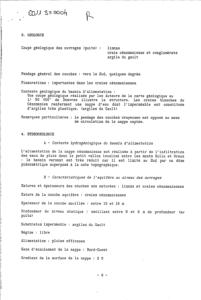
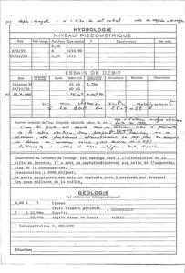
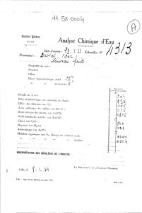
Nature
PUITSProfondeur atteinte
23.9 mDiamčtre de l'ouvrage
200 mmDate fin de travaux
1958-01-01 00:00:00.0Mode d'exécution
TREPAN.Etat de l'ouvrage
ACCES, EXPLOITE, MESURE, POMPE, PRELEV, TUBE-METAL, CREPINE.Utilisation
EAU-COLLECTIVEObjet de la recherche
Non renseignéObjet de l'exploitation
EAU.Objet de la reconnaissance
Non renseignéGisement
Non renseignéRéférences
Non renseignéRéférencé comme point d'eau
 OUI
OUI
Niveau d'eau mesuré par rapport au sol
4.9 m - 1958-12-22 00:00:00.0Coupe
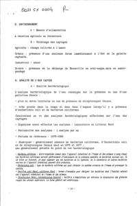
Z Origine
Non renseignéAuteur
Non renseignéDate
Non renseignéDocument(s) numérisé(s)
31 document(s)| Vignette | Nom | Type | Poids |
|---|---|---|---|
|
G0065465.TIF |
|
27 Ko |
|
G0065466.TIF |
|
46 Ko |
|
G0065467.TIF |
|
48 Ko |
|
G0065468.TIF |
|
41 Ko |
|
G0065469.TIF |
|
47 Ko |
|
G0065470.TIF |
|
30 Ko |
|
G0065471.TIF |
|
154 Ko |
|
G0065472.TIF |
|
144 Ko |
|
G0065473.TIF |
|
26 Ko |
|
G0065474.TIF |
|
35 Ko |
|
G0065475.TIF |
|
41 Ko |
|
G0065476.TIF |
|
36 Ko |
|
G0065477.TIF |
|
10 Ko |
|
G0065478.TIF |
|
35 Ko |
|
G0065479.TIF |
|
21 Ko |
|
G0065481.TIF |
|
134 Ko |
|
G0065482.TIF |
|
22 Ko |
|
G0065483.TIF |
|
43 Ko |
|
G0065484.TIF |
|
45 Ko |
|
G0065485.TIF |
|
45 Ko |
|
G0065486.TIF |
|
39 Ko |
|
G0065487.TIF |
|
160 Ko |
|
G0065488.TIF |
|
25 Ko |
|
G0065489.TIF |
|
43 Ko |
|
G0065490.TIF |
|
41 Ko |
|
G0065491.TIF |
|
29 Ko |
|
G0065492.TIF |
|
64 Ko |
|
G0065493.TIF |
|
60 Ko |
|
G0065494.TIF |
|
23 Ko |
|
G0065495.TIF |
|
50 Ko |
|
G0065496.TIF |
|
59 Ko |