


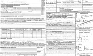
Identifiant national de l'ouvrage
BSS000LDXS
Ancien code - avant 2017
01511X0079
Localisation
Département
EURE (27) - SGR/HNOCommune
SAINT MARCEL (27562)Nom local
HYNuméro de carte
0151Huitičme
1XRégion naturelle
HUREPOIXBassin versant
SEINEAdresse ou Lieu-dit
SOURCE DU PERE COTONCoordonnées
| Systčme | X (m) | Y (m) |
|---|---|---|
| Lambert 2 étendu | 534338 | 2455137 |
| Lambert 1 - Nord | 534390 | 154900 |
| Lambert-93 | 585922 | 6889018 |
| Systčme | Latitude | Longitude |
|---|---|---|
| WGS84 | 49.09084171 | 49° 5' 27'' N | 1.43810774 | 1° 26' 17'' E |
Altitude
81.0 m - Précision EPDDescription technique
Nature
SOURCEProfondeur atteinte
Non renseignéDiamčtre de l'ouvrage
Non renseignéDate fin de travaux
1957-01-01 00:00:00.0Mode d'exécution
Non renseignéEtat de l'ouvrage
ACCES, EXPLOITE, MESURE, PRELEV.Utilisation
EAU-COLLECTIVEObjet de la recherche
Non renseignéObjet de l'exploitation
EAU.Objet de la reconnaissance
Non renseignéGisement
Non renseignéRéférences
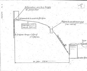
SOURCE CAPTEE PAR PUITS COMPLEX ERéférencé comme point d'eau
 OUI
OUI
Niveau d'eau mesuré par rapport au sol
Non renseignéCoupe
Z Origine
Non renseignéAuteur
Non renseignéDate
Non renseignéDocument(s) numérisé(s)
33 document(s)| Vignette | Nom | Type | Poids |
|---|---|---|---|
|
G0222056.TIF |
|
193 Ko |

|
G0222057.TIF |
|
36 Ko |
|
G0222058.TIF |
|
85 Ko |
|
G0222059.TIF |
|
79 Ko |

|
G0222060.TIF |
|
84 Ko |
|
G0222061.TIF |
|
85 Ko |
|
G0222062.TIF |
|
94 Ko |

|
G0222063.TIF |
|
103 Ko |
|
G0222064.TIF |
|
58 Ko |
|
G0222065.TIF |
|
60 Ko |
|
G0222066.TIF |
|
73 Ko |
|
G0222067.TIF |
|
61 Ko |

|
G0222068.TIF |
|
60 Ko |

|
G0222069.TIF |
|
77 Ko |

|
G0222070.TIF |
|
66 Ko |

|
G0222071.TIF |
|
77 Ko |

|
G0222072.TIF |
|
69 Ko |
|
G0222073.TIF |
|
69 Ko |

|
G0222074.TIF |
|
73 Ko |

|
G0222075.TIF |
|
88 Ko |

|
G0222076.TIF |
|
60 Ko |
|
G0222077.TIF |
|
62 Ko |
|
G0222078.TIF |
|
83 Ko |
|
G0222079.TIF |
|
81 Ko |
|
G0222080.TIF |
|
84 Ko |

|
G0222081.TIF |
|
91 Ko |
|
G0222082.TIF |
|
52 Ko |

|
G0222083.TIF |
|
65 Ko |

|
G0222084.TIF |
|
85 Ko |
|
G0222085.TIF |
|
33 Ko |

|
G0222086.TIF |
|
61 Ko |

|
G0222087.TIF |
|
58 Ko |

|
G0222088.TIF |
|
273 Ko |