


Identifiant national de l'ouvrage
BSS000PKUK
Ancien code - avant 2017
01841X0242
Localisation
Département
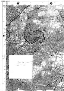
SEINE SAINT DENIS (93) - SGR/IDFCommune
MONTFERMEIL (93047)Nom local
F1Numéro de carte
0184Huitičme
1XRégion naturelle
SOISSONNAISBassin versant
Non renseignéAdresse ou Lieu-dit
MOULIN DU SEMPINCoordonnées
| Systčme | X (m) | Y (m) |
|---|---|---|
| Lambert 2 étendu | 618381 | 2432746 |
| Lambert 1 - Nord | 618370 | 132510 |
| Lambert-93 | 669722 | 6865939 |
| Systčme | Latitude | Longitude |
|---|---|---|
| WGS84 | 48.89274479 | 48° 53' 33'' N | 2.58703614 | 2° 35' 13'' E |
Altitude
111.0 m - Précision IGNDescription technique
Nature
FORAGEProfondeur atteinte
76.0 mDiamčtre de l'ouvrage
180 mmDate fin de travaux
2001-07-04 00:00:00.0Mode d'exécution
Non renseignéEtat de l'ouvrage
CREPINE, POMPE, EXPLOITE.Utilisation
EAU-IRRIGATION.Objet de la recherche
Non renseignéObjet de l'exploitation
EAU.Objet de la reconnaissance
Non renseignéGisement
Non renseignéRéférences
DECLARATION CODE MINIER 93-002-01Référencé comme point d'eau
 OUI
OUI
Niveau d'eau mesuré par rapport au sol
59.6 m -Coupe
Z Origine
Non renseignéAuteur
SARL SANFORDate
Non renseignéDocument(s) numérisé(s)
26 document(s)| Vignette | Nom | Type | Poids |
|---|---|---|---|
|
A201277.TIF |
|
50 Ko |

|
A201278.TIF |
|
297 Ko |
|
A201279.TIF |
|
325 Ko |
|
R99807.TIF |
|
25 Ko |
|
R99808.TIF |
|
62 Ko |
|
R99809.TIF |
|
328 Ko |
|
R99810.TIF |
|
20 Ko |

|
R99811.TIF |
|
37 Ko |
|
R99812.TIF |
|
15 Ko |
|
R99813.TIF |
|
316 Ko |
|
R99814.TIF |
|
47 Ko |
|
R99815.TIF |
|
23 Ko |
|
R99816.TIF |
|
20 Ko |
|
R99817.TIF |
|
64 Ko |
|
R99818.TIF |
|
35 Ko |
|
R99819.TIF |
|
28 Ko |
|
R99820.TIF |
|
29 Ko |
|
R99821.TIF |
|
87 Ko |
|
R99822.TIF |
|
56 Ko |

|
R99823.TIF |
|
47 Ko |
|
R99824.TIF |
|
27 Ko |

|
R99825.TIF |
|
41 Ko |
|
R99826.TIF |
|
52 Ko |
|
R99827.TIF |
|
27 Ko |
|
R99828.TIF |
|
59 Ko |
|
R99829.TIF |
|
64 Ko |
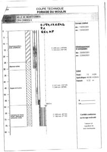
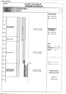
Log géologique numérisé
Nombre de passes :
5 - Afficher le log validéNombre de niveaux :
4| Profondeur | Lithologie | Stratigraphie |
|---|---|---|
| De 0 ŕ 25 m | REMBLAIS (BOIS, BETON, PLASTIQUE) | QUATERNAIRE |
| De 25 ŕ 31 m | MARNES VERTES | STAMPIEN |
| De 31 ŕ 59 m | MARNES ET GYPSE | LUDIEN |
| De 59 ŕ 76 m | CALCAIRE DE SAINT OUEN | MARINESIEN |