


Identifiant national de l'ouvrage
BSS000RRCT
Ancien code - avant 2017
02206X0116
Localisation
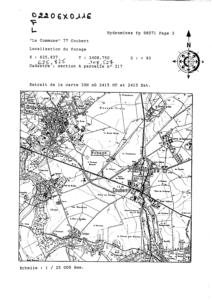
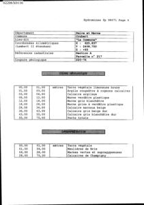
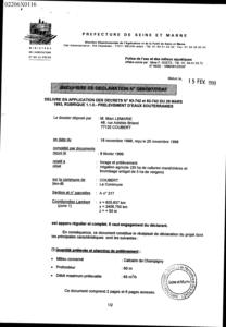
Département
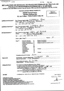
SEINE ET MARNE (77) - SGR/IDFCommune
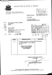
COUBERT (77127)Nom local
FNuméro de carte
0220Huitičme
6XRégion naturelle
BRIEBassin versant
Non renseignéAdresse ou Lieu-dit
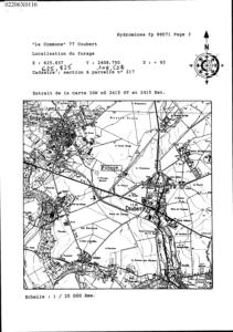
"LA COMMUNE"Coordonnées
| Systčme | X (m) | Y (m) |
|---|---|---|
| Lambert 2 étendu | 625836 | 2408749 |
| Lambert 1 - Nord | 625825 | 108527 |
| Lambert-93 | 676970 | 6841896 |
| Systčme | Latitude | Longitude |
|---|---|---|
| WGS84 | 48.67680776 | 48° 40' 36'' N | 2.68718744 | 2° 41' 13'' E |
Altitude
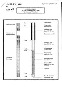
93.0 m - Précision IGNDescription technique
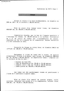
Nature
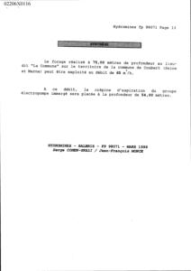
FORAGEProfondeur atteinte
75.0 mDiamčtre de l'ouvrage
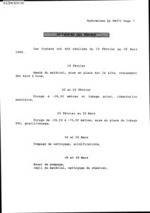
315 mmDate fin de travaux
1999-03-09 00:00:00.0Mode d'exécution
ROTATION.Etat de l'ouvrage
CREPINE, EXPLOITE, POMPE.Utilisation
EAU-IRRIGATION.Objet de la recherche
Non renseignéObjet de l'exploitation
EAU.Objet de la reconnaissance
Non renseignéGisement
Non renseignéRéférences
DECLARATION CODE MINIER 77-06-99Référencé comme point d'eau
 OUI
OUI
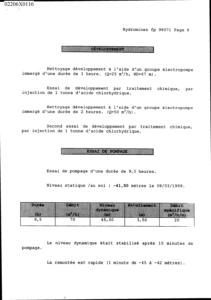
Niveau d'eau mesuré par rapport au sol
41.5 m - 1999-03-08 00:00:00.0Coupe
Z Origine
93.0 - Précision : IGNAuteur
HYDROMINESDate
1999-03-15 00:00:00.0Document(s) numérisé(s)
41 document(s)| Vignette | Nom | Type | Poids |
|---|---|---|---|
|
A78784.TIF |
|
130 Ko |
|
A78785.TIF |
|
103 Ko |
|
A78786.TIF |
|
67 Ko |
|
R132986.TIF |
|
133 Ko |
|
R132987.TIF |
|
18 Ko |
|
R132988.TIF |
|
31 Ko |
|
R132989.TIF |
|
106 Ko |
|
R132990.TIF |
|
36 Ko |
|
R132991.TIF |
|
87 Ko |
|
R132992.TIF |
|
36 Ko |
|
R132993.TIF |
|
19 Ko |
|
R132994.TIF |
|
59 Ko |
|
R132995.TIF |
|
32 Ko |
|
R132996.TIF |
|
16 Ko |
|
R132997.TIF |
|
50 Ko |
|
R132998.TIF |
|
36 Ko |
|
R132999.TIF |
|
18 Ko |
|
R133000.TIF |
|
12 Ko |
|
R133001.TIF |
|
10 Ko |
|
R133002.TIF |
|
5 Ko |
|
R133003.TIF |
|
38 Ko |
|
R133004.TIF |
|
35 Ko |
|
R133005.TIF |
|
58 Ko |
|
R133006.TIF |
|
65 Ko |
|
R133007.TIF |
|
57 Ko |
|
R133008.TIF |
|
55 Ko |
|
R133009.TIF |
|
48 Ko |
|
R133010.TIF |
|
42 Ko |
|
R133011.TIF |
|
4 Ko |
|
R133012.TIF |
|
57 Ko |
|
R133013.TIF |
|
23 Ko |

|
R133014.TIF |
|
65 Ko |
|
R133015.TIF |
|
34 Ko |
|
R133016.TIF |
|
53 Ko |
|
R133017.TIF |
|
53 Ko |
|
R133018.TIF |
|
93 Ko |
|
R133019.TIF |
|
84 Ko |
|
R133020.TIF |
|
75 Ko |
|
R133021.TIF |
|
85 Ko |
|
R133022.TIF |
|
63 Ko |
|
R133023.TIF |
|
55 Ko |
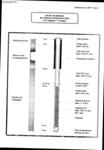
Log géologique numérisé
Nombre de passes :
4 - Afficher le log validéNombre de niveaux :
3| Profondeur | Lithologie | Stratigraphie |
|---|---|---|
| De 0 ŕ 6 m | CALCAIRE DE BRIE | STAMPIEN |
| De 6 ŕ 28 m | MARNES VERTES ET SUPRAGYPSEUSES | de STAMPIEN a LUDIEN |
| De 28 ŕ 75 m | CALCAIRES DE CHAMPIGNY | LUDIEN |