


Identifiant national de l'ouvrage
BSS001AFRS
Ancien code - avant 2017
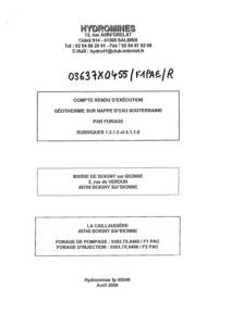
03637X0455
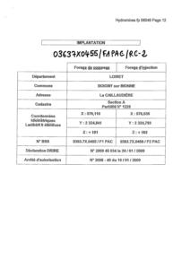
Localisation
Département
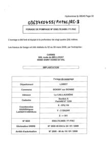
LOIRET (45) - SGR/CENCommune
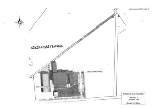
BOIGNY SUR BIONNE (45034)Nom local
F1PACNuméro de carte
0363Huitičme
7XRégion naturelle
BEAUCEBassin versant
Non renseignéAdresse ou Lieu-dit
LA CALLAUDIERE PARCELLE A-1225Coordonnées
| Systčme | X (m) | Y (m) |
|---|---|---|
| Lambert 2 étendu | 576110 | 2324841 |
| Lambert 2 - Centre | 576110 | 324841 |
| Lambert-93 | 626575 | 6758465 |
| Systčme | Latitude | Longitude |
|---|---|---|
| WGS84 | 47.92246208 | 47° 55' 20'' N | 2.0168886 | 2° 1' 0'' E |
Altitude
101.0 m - Précision EPDDescription technique
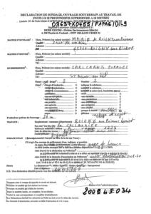
Nature
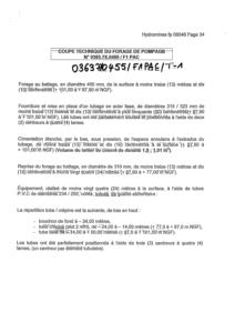
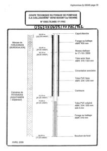
FORAGEProfondeur atteinte
24.0 mDiamčtre de l'ouvrage
234 mmDate fin de travaux
2009-03-15 00:00:00.0Mode d'exécution
BATTAGE.Etat de l'ouvrage
EXPLOITE, TUBE-PLASTIQUE, MESURE, CIMENTATION-EXTRADOS.Utilisation
POMPE-A-CHALEUR,AQUIFERE.Objet de la recherche
Non renseignéObjet de l'exploitation
EAU,GEOTHERMIE-TBE.Objet de la reconnaissance
Non renseignéGisement
Non renseignéRéférences
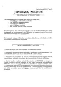
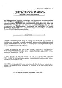
FORAGE DE POMPAGE POUR POMPE A CHALEUR - HYDROMINES FP 08046Référencé comme point d'eau
 OUI
OUI
Niveau d'eau mesuré par rapport au sol
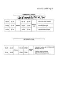
Non renseignéCoupe
Z Origine
101.0 - Précision : M01Auteur
FOREURDate
2009-03-15 00:00:00.0Document(s) numérisé(s)
23 document(s)| Vignette | Nom | Type | Poids |
|---|---|---|---|
|
B129135.TIF |
|
35 Ko |
|
B129136.TIF |
|
63 Ko |
|
B129137.TIF |
|
56 Ko |
|
B129138.TIF |
|
58 Ko |
|
B129139.TIF |
|
61 Ko |
|
B129140.TIF |
|
67 Ko |
|
B129141.TIF |
|
82 Ko |
|
B129142.TIF |
|
74 Ko |
|
B129143.TIF |
|
69 Ko |
|
B129144.TIF |
|
18 Ko |
|
B129145.TIF |
|
94 Ko |
|
B129146.TIF |
|
31 Ko |
|
B129147.TIF |
|
39 Ko |
|
B129148.TIF |
|
23 Ko |
|
B129149.TIF |
|
51 Ko |
|
B129150.TIF |
|
116 Ko |
|
B129151.TIF |
|
264 Ko |
|
B129152.TIF |
|
45 Ko |
|
B129153.TIF |
|
602 Ko |
|
B129154.TIF |
|
68 Ko |
|
B129155.TIF |
|
60 Ko |
|
B129156.TIF |
|
62 Ko |
|
B129157.TIF |
|
165 Ko |