


Identifiant national de l'ouvrage
BSS001FMQH
Ancien code - avant 2017
04587X0138
Localisation
Département
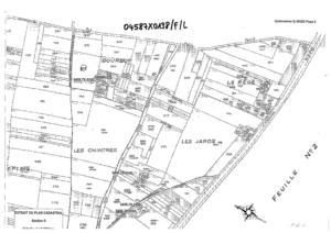
INDRE ET LOIRE (37) - SGR/CENCommune
NOIZAY (37171)Nom local
FNuméro de carte
0458Huitičme
7XRégion naturelle
ANJOU-TOURAINEBassin versant
Non renseignéAdresse ou Lieu-dit
BOURBUR D 617Coordonnées
| Systčme | X (m) | Y (m) |
|---|---|---|
| Lambert 2 étendu | 492250 | 2268490 |
| Lambert 2 - Centre | 492250 | 268490 |
| Lambert-93 | 542311 | 6702857 |
| Systčme | Latitude | Longitude |
|---|---|---|
| WGS84 | 47.4072633 | 47° 24' 26'' N | 0.90875863 | 0° 54' 31'' E |
Altitude
53.0 m - Précision EPDDescription technique
Nature
FORAGEProfondeur atteinte
38.0 mDiamčtre de l'ouvrage
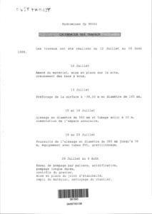
225 mmDate fin de travaux
1999-08-06 00:00:00.0Mode d'exécution
BOUE,ROTATION.Etat de l'ouvrage
TUBE-PLASTIQUE, MESURE, EXPLOITE.Utilisation
EAU-ASPERSION.Objet de la recherche
Non renseignéObjet de l'exploitation
EAU.Objet de la reconnaissance
Non renseignéGisement
Non renseignéRéférences
HYDROMINES - RAPPORT DES TRAVAUX FP 98051 - SEPTEMBRE 1999 + HYDROMINES = FP 06203 BISRéférencé comme point d'eau
 OUI
OUI
Niveau d'eau mesuré par rapport au sol
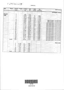
Non renseignéCoupe
Z Origine
53.0 - Précision : M01Auteur
HYDROMINESDate
1999-07-13 00:00:00.0Document(s) numérisé(s)
43 document(s)| Vignette | Nom | Type | Poids |
|---|---|---|---|
|
B141438.TIF |
|
92 Ko |

|
B141439.TIF |
|
46 Ko |

|
B141440.TIF |
|
51 Ko |
|
B141441.TIF |
|
36 Ko |

|
B141442.TIF |
|
28 Ko |
|
B141443.TIF |
|
64 Ko |

|
B141444.TIF |
|
22 Ko |

|
B141445.TIF |
|
70 Ko |

|
B141446.TIF |
|
63 Ko |
|
B141447.TIF |
|
33 Ko |
|
B141448.TIF |
|
45 Ko |
|
B141449.TIF |
|
27 Ko |
|
B141450.TIF |
|
32 Ko |

|
B141451.TIF |
|
121 Ko |

|
B141452.TIF |
|
43 Ko |

|
B141453.TIF |
|
59 Ko |
|
B141454.TIF |
|
46 Ko |

|
B141455.TIF |
|
62 Ko |

|
B141456.TIF |
|
40 Ko |

|
B141457.TIF |
|
37 Ko |

|
B141458.TIF |
|
27 Ko |
|
B141459.TIF |
|
38 Ko |
|
B141460.TIF |
|
24 Ko |
|
B141461.TIF |
|
49 Ko |

|
B141462.TIF |
|
73 Ko |
|
B141463.TIF |
|
63 Ko |

|
B141464.TIF |
|
90 Ko |

|
B141465.TIF |
|
63 Ko |

|
T88704.TIF |
|
199 Ko |
|
T88705.TIF |
|
224 Ko |

|
T88706.TIF |
|
40 Ko |

|
T88707.TIF |
|
49 Ko |

|
T88708.TIF |
|
55 Ko |
|
T88709.TIF |
|
106 Ko |
|
T88710.TIF |
|
90 Ko |

|
T88711.TIF |
|
32 Ko |
|
T88712.TIF |
|
50 Ko |

|
T88713.TIF |
|
29 Ko |
|
T88714.TIF |
|
32 Ko |
|
T88715.TIF |
|
59 Ko |
|
T88716.TIF |
|
44 Ko |

|
T88717.TIF |
|
61 Ko |

|
T88718.TIF |
|
73 Ko |