


Identifiant national de l'ouvrage
BSS001FMQK
Ancien code - avant 2017
04587X0140
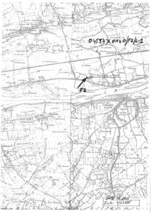
Localisation
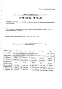
Département
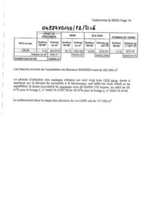
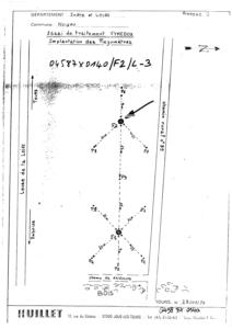
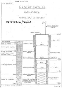
INDRE ET LOIRE (37) - SGR/CENCommune
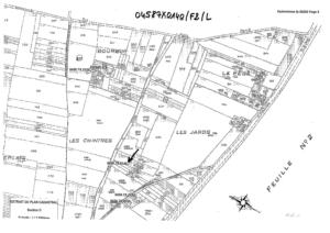
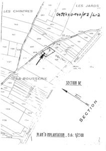
NOIZAY (37171)Nom local
F2Numéro de carte
0458Huitičme
7XRégion naturelle
ANJOU-TOURAINEBassin versant
Non renseignéAdresse ou Lieu-dit
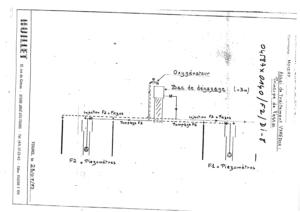
LES JARDS (LA BOUSSERIE) - PARCELLE D2-708 - FORAGE F2Coordonnées
| Systčme | X (m) | Y (m) |
|---|---|---|
| Lambert 2 étendu | 491780 | 2268260 |
| Lambert 2 - Centre | 491780 | 268260 |
| Lambert-93 | 541839 | 6702631 |
| Systčme | Latitude | Longitude |
|---|---|---|
| WGS84 | 47.40511778 | 47° 24' 18'' N | 0.90258778 | 0° 54' 9'' E |
Altitude
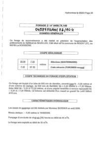
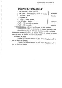
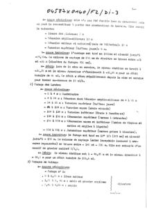
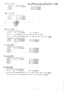
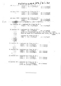
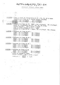
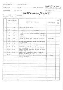
53.0 m - Précision EPDDescription technique
Nature
FORAGEProfondeur atteinte
7.3 mDiamčtre de l'ouvrage
630 mmDate fin de travaux
1976-10-11 00:00:00.0Mode d'exécution
BENOTO.Etat de l'ouvrage
TUBE-METAL, MESURE, NON-EXPLOITE, ABANDONNE, PRELEV.Utilisation
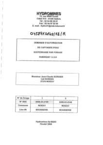
EAU-COLLECTIVEObjet de la recherche
Non renseignéObjet de l'exploitation
EAU.Objet de la reconnaissance
Non renseignéGisement
Non renseignéRéférences
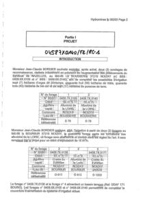
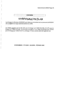
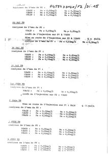
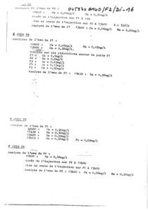
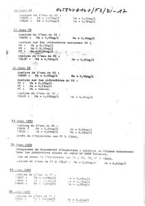
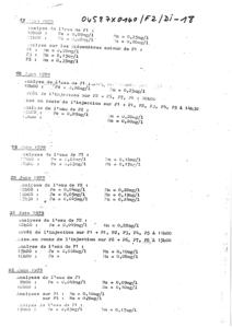
CF DOSSIER 04587X0105/F1-F2 ( FORAGE F1) - ECHANTILLONS BRGM N° 41379 A 41389 + HYDROMINES = FP 06203 (FEVRIER 2008)Référencé comme point d'eau
 OUI
OUI
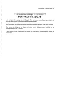
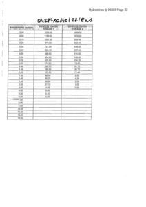
Niveau d'eau mesuré par rapport au sol
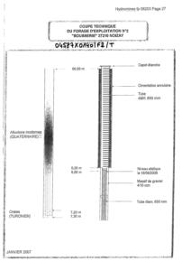
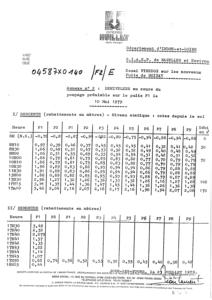
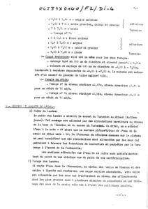
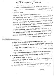
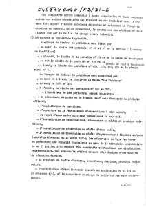
2.91 m - 1976-10-25 00:00:00.0Coupe
Z Origine
53.0 - Précision : C10Auteur
J.MANIVITDate
1976-12-31 00:00:00.0Document(s) numérisé(s)
52 document(s)| Vignette | Nom | Type | Poids |
|---|---|---|---|
|
B141539.TIF |
|
92 Ko |
|
B141540.TIF |
|
55 Ko |
|
B141541.TIF |
|
51 Ko |
|
B141542.TIF |
|
28 Ko |
|
B141543.TIF |
|
35 Ko |
|
B141544.TIF |
|
61 Ko |
|
B141545.TIF |
|
20 Ko |
|
B141546.TIF |
|
40 Ko |
|
B141547.TIF |
|
82 Ko |
|
B141548.TIF |
|
71 Ko |
|
B141549.TIF |
|
35 Ko |
|
B141550.TIF |
|
43 Ko |
|
B141551.TIF |
|
51 Ko |
|
B141552.TIF |
|
107 Ko |
|
B141553.TIF |
|
21 Ko |
|
B141554.TIF |
|
34 Ko |
|
B141555.TIF |
|
57 Ko |
|
B141556.TIF |
|
43 Ko |
|
B141557.TIF |
|
29 Ko |
|
B141558.TIF |
|
41 Ko |
|
B141559.TIF |
|
20 Ko |
|
B47807.TIF |
|
87 Ko |
|
B47808.TIF |
|
17 Ko |
|
B47809.TIF |
|
49 Ko |
|
B47810.TIF |
|
71 Ko |
|
B47811.TIF |
|
73 Ko |
|
B47812.TIF |
|
85 Ko |
|
B47813.TIF |
|
77 Ko |
|
B47814.TIF |
|
73 Ko |
|
B47815.TIF |
|
40 Ko |
|
B47816.TIF |
|
80 Ko |
|
B47817.TIF |
|
93 Ko |
|
B47818.TIF |
|
22 Ko |
|
B47819.TIF |
|
59 Ko |
|
B47820.TIF |
|
54 Ko |
|
B47821.TIF |
|
23 Ko |
|
B47822.TIF |
|
53 Ko |
|
B47823.TIF |
|
38 Ko |
|
B47824.TIF |
|
48 Ko |
|
B47825.TIF |
|
47 Ko |
|
B47826.TIF |
|
43 Ko |
|
B47827.TIF |
|
51 Ko |
|
B47828.TIF |
|
51 Ko |
|
B47829.TIF |
|
215 Ko |
|
B47830.TIF |
|
55 Ko |
|
B47831.TIF |
|
49 Ko |
|
B47832.TIF |
|
83 Ko |
|
B47833.TIF |
|
83 Ko |
|
B47834.TIF |
|
57 Ko |
|
B47835.TIF |
|
56 Ko |
|
B47836.TIF |
|
70 Ko |
|
B47837.TIF |
|
48 Ko |