


Identifiant national de l'ouvrage
BSS001RDPQ
Ancien code - avant 2017
06497X4004
Localisation
Département
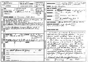
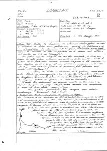
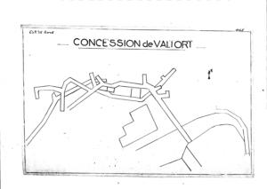
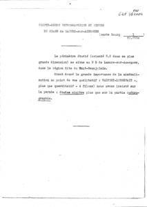
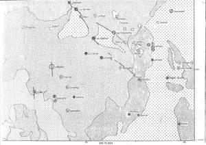
RHONE (69) - SGR/RHACommune
POULE LES ECHARMEAUX (69160)Nom local
GTNuméro de carte
0649Huitičme
7XRégion naturelle
Non renseignéBassin versant
Non renseignéAdresse ou Lieu-dit
LONGEFAY (LONGEFAIT)Coordonnées
| Systčme | X (m) | Y (m) |
|---|---|---|
| Lambert 2 étendu | 767750 | 2127800 |
| Lambert 2 - Centre | 767750 | 127800 |
| Lambert-93 | 816391 | 6559970 |
| Systčme | Latitude | Longitude |
|---|---|---|
| WGS84 | 46.1295448 | 46° 7' 46'' N | 4.50753476 | 4° 30' 27'' E |
Altitude
660.0 m - Précision EPDDescription technique
Nature
GITE-MINIERProfondeur atteinte
70.0 mDiamčtre de l'ouvrage
Non renseignéDate fin de travaux
1868-01-01 00:00:00.0Mode d'exécution
PUITS,TRACAGE.Etat de l'ouvrage
ANCIENNE-EXPLOITATION, INACCES.Utilisation
Non renseignéObjet de la recherche
Non renseignéObjet de l'exploitation
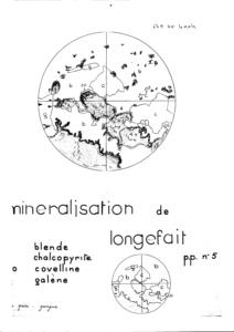
PLOMB,ZINC,CUIVRE,ARGENT,BARYTINE.Objet de la reconnaissance
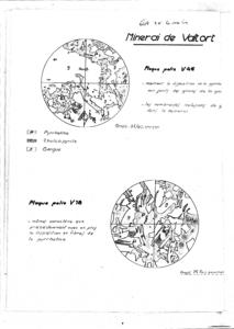
Non renseignéGisement
FILON.Références
ARCHIVES SNEA,7 - J.PAQUIER FICHE D'INDICE - C.JOANNES (1981) THESE,ORLEANS - ARCHIVES BOURBONNAIS-LYONNAIS-MORVAN - JM.BOIRAT (1979) RAP.BRGM.SGN/GMX/GIT N°601 - FICHE DAM/DL/CLERMONTRéférencé comme point d'eau
 NON
NON
Niveau d'eau mesuré par rapport au sol
Non renseignéCoupe
Z Origine
Non renseignéAuteur
Non renseignéDate
Non renseignéDocument(s) numérisé(s)
39 document(s)| Vignette | Nom | Type | Poids |
|---|---|---|---|
|
E15030.TIF |
|
92 Ko |
|
E15031.TIF |
|
78 Ko |
|
E15032.TIF |
|
69 Ko |
|
E15033.TIF |
|
52 Ko |
|
E15034.TIF |
|
62 Ko |
|
E15035.TIF |
|
67 Ko |
|
E15036.TIF |
|
66 Ko |
|
E15037.TIF |
|
63 Ko |
|
E15038.TIF |
|
81 Ko |
|
E15039.TIF |
|
79 Ko |
|
E15040.TIF |
|
89 Ko |
|
E15041.TIF |
|
44 Ko |
|
E15042.TIF |
|
58 Ko |
|
E15043.TIF |
|
26 Ko |
|
E15044.TIF |
|
67 Ko |
|
E15045.TIF |
|
32 Ko |
|
E15046.TIF |
|
28 Ko |
|
E15047.TIF |
|
60 Ko |
|
E15048.TIF |
|
54 Ko |
|
E15049.TIF |
|
93 Ko |
|
E15050.TIF |
|
60 Ko |
|
E15051.TIF |
|
50 Ko |
|
E15052.TIF |
|
60 Ko |
|
E15053.TIF |
|
69 Ko |
|
E15054.TIF |
|
44 Ko |
|
E15055.TIF |
|
67 Ko |
|
E15056.TIF |
|
22 Ko |
|
E15057.TIF |
|
67 Ko |
|
E15058.TIF |
|
56 Ko |
|
E15059.TIF |
|
15 Ko |
|
E15060.TIF |
|
59 Ko |
|
E15061.TIF |
|
71 Ko |
|
E15062.TIF |
|
78 Ko |
|
E15063.TIF |
|
70 Ko |
|
E15064.TIF |
|
43 Ko |
|
E15065.TIF |
|
49 Ko |
|
E15066.TIF |
|
37 Ko |
|
E15067.TIF |
|
44 Ko |
|
E15068.TIF |
|
386 Ko |