


Identifiant national de l'ouvrage
BSS002PJWM
Ancien code - avant 2017
12288X0076
Localisation
Département
LA REUNION (974) - SGR/REUCommune
SAINT LOUIS (97414)Nom local
FC2Numéro de carte
1228Huitičme
8XRégion naturelle
REUNIONBassin versant
Non renseignéAdresse ou Lieu-dit
FORAGE COCOS 2Coordonnées
| Systčme | X (m) | Y (m) |
|---|---|---|
| Réunion-92 | 336724 | 7646209 |
| Systčme | Latitude | Longitude |
|---|---|---|
| WGS84 | -21.27856282 | 21° 16' 42'' S | 55.42617322 | 55° 25' 34'' E |
Altitude
77.25 m - Précision RNGDescription technique
Nature
FORAGEProfondeur atteinte
170.0 mDiamčtre de l'ouvrage
Non renseignéDate fin de travaux
1989-02-18 00:00:00.0Mode d'exécution
MOUSSE,TREPAN-MOLETTES.Etat de l'ouvrage
ACCES, MESURE, PRELEV, EXPLOITE.Utilisation
EAU-COLLECTIVEObjet de la recherche
Non renseignéObjet de l'exploitation
Non renseignéObjet de la reconnaissance
RESSOURCE-EAU.Gisement
Non renseignéRéférences
VOIR RAPPORT BRGM 88 REU 28 -VOIR RAPP BRGM 84 SGN 307 GPH, 85 REU 23 -FORAGE PREVU POUR L'IRRIGATIONRéférencé comme point d'eau
 OUI
OUI
Niveau d'eau mesuré par rapport au sol
67.8 m - 1989-01-21 00:00:00.0Coupe
Z Origine
77.25 - Précision : RNGAuteur
VERDIERDate
1989-02-18 00:00:00.0Document(s) numérisé(s)
45 document(s)| Vignette | Nom | Type | Poids |
|---|---|---|---|
|
E40232.TIF |
|
12 Ko |
|
E40233.TIF |
|
10 Ko |
|
E40234.TIF |
|
65 Ko |
|
E40235.TIF |
|
63 Ko |
|
E40236.TIF |
|
30 Ko |
|
E40237.TIF |
|
28 Ko |
|
E40238.TIF |
|
42 Ko |
|
E40239.TIF |
|
219 Ko |
|
E40240.TIF |
|
703 Ko |
|
E40241.TIF |
|
121 Ko |
|
E40242.TIF |
|
39 Ko |
|
E40243.TIF |
|
116 Ko |
|
E40244.TIF |
|
62 Ko |
|
E40245.TIF |
|
54 Ko |
|
E40246.TIF |
|
296 Ko |
|
E40247.TIF |
|
106 Ko |
|
E40248.TIF |
|
32 Ko |
|
E40249.TIF |
|
32 Ko |
|
E40250.TIF |
|
30 Ko |
|
E40251.TIF |
|
29 Ko |
|
E40252.TIF |
|
56 Ko |
|
E40253.TIF |
|
73 Ko |
|
E40254.TIF |
|
37 Ko |
|
E40255.TIF |
|
38 Ko |
|
E40256.TIF |
|
70 Ko |
|
E40257.TIF |
|
190 Ko |
|
E40258.TIF |
|
29 Ko |
|
E40259.TIF |
|
64 Ko |
|
E40260.TIF |
|
32 Ko |
|
E40261.TIF |
|
63 Ko |
|
E40262.TIF |
|
58 Ko |
|
E40263.TIF |
|
28 Ko |
|
E40264.TIF |
|
88 Ko |
|
E40265.TIF |
|
68 Ko |
|
E40266.TIF |
|
89 Ko |
|
E40267.TIF |
|
85 Ko |
|
E40268.TIF |
|
82 Ko |
|
E40269.TIF |
|
4 Ko |
|
E40270.TIF |
|
84 Ko |
|
E40271.TIF |
|
111 Ko |
|
E40272.TIF |
|
112 Ko |
|
E40273.TIF |
|
112 Ko |
|
E40274.TIF |
|
67 Ko |
|
E40275.TIF |
|
200 Ko |
|
E40276.TIF |
|
101 Ko |
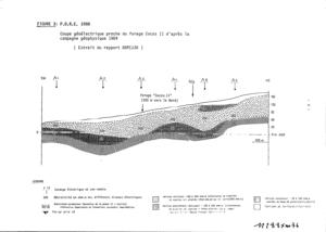
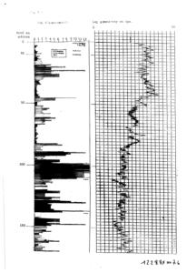
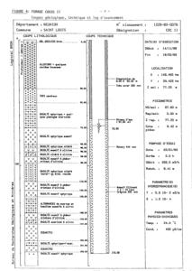
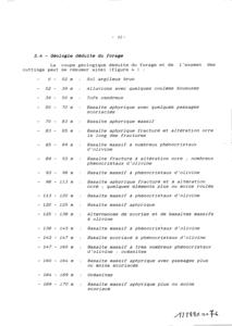
Log géologique numérisé
Nombre de niveaux :
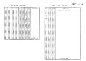
5| Profondeur | Lithologie | Stratigraphie |
|---|---|---|
| De 0 ŕ 2 m | SUPERF/ TERRE? ARGILEUX BRUN | QUATERNAIRE |
| De 2 ŕ 39 m | PRE/SABLE/BLOC/BRACGE-VOLCA/ | PHASE-IV |
| De 39 ŕ 50 m | TUF | PHASE-IV |
| De 50 ŕ 147 m | BASALTE, APHYRIQUE, DIVINE | PHASE-IV |
| De 147 ŕ 170 m | OCEANITE | PHASE-II |